Evaluation of an array-antenna GPR
system (SAR-GPR)
Motoyuki SATOa*, Xuan FENGa , Takao KOBAYASHIa,
Zheng-Shu ZHOU a, Timofei G. SAVELYEV a and Jun FUJIWARAb
a Tohoku University, Sendai 980-8576, JAPAN
b Tokyo Gas Co. Ltd., Arakawa-ku, Tokyo 116-0003, JAPAN
Abstract
SAR-GPR is a sensor system composed of a GPR
and a metal detector for landmine detection. The GPR employs
an array antenna for advanced signal processing for better subsurface imaging.
This system combined with synthetic aperture radar algorithm, can suppress
clutter and can image buried objects in strongly inhomogeneous material.
SAR-GPR is a stepped frequency radar system, whose RF component is a newly
developed compact vector network analyzers. The size of the system is 30cm x
30cm x 30cm, composed from 6 Vivaldi antennas and 3 vector network analyzers.
The weight of the system is about 30kg, and it can be mounted on a robotic arm
on a small unmanned vehicle. The field test of this system was carried out in March 2005 in Japan, and some results on this test are reported.
Keywords: GPR,
Metal detector, Array antenna, Vehicle, Landmine detection
1. INTRODUCTION
A MEXT
(the Ministry of Education Culture, Sports, Science and Technology) Committee
of Experts on Humanitarian Demining Technology presented the report:"Promoting Research and
Development for Humanitarian Demining" on May 27, 2002. The report showed
that research and development based on Japanese advanced science and technology
should be carried out for supporting safety and effective activities of
Humanitarian Demining in mine affected countries and that the technology
acquired therefrom is expected to provide a field trial in a country or
countries that have suffered from antipersonnel mines around FY2005 and FY2007.
According to a sector designated to JST (Japan Science and Technology Agency) from the MEXT on ground of
this report, JST set a research area, invited research proposals and started the
research and development.
Under this research project, we are
developing mine detection systems based on advanced sensing technology and
access-and-control technology. As a short-term R&D project, the sensor
units use new GPR (ground penetrating radar) with existing MD (metal detector)
technology in a single system. The concept, in which the deminers are given a
continuous supply of detailed underground imaging data. As a middle-term
R&D project, we are developing sensors that can detect explosives in
landmines to improve detection efficiency. The research and development have
been done by cooperation of universities, industries, and government.
SAR-GPR is a sensor system developed to be
equipped on a compact vehicle named “Mine Hunter Vehicle” and the others. This system
is composed of a GPR and a metal detector for landmine detection. The GPR
employs an array antenna combined with synthetic aperture radar
algorithm, and it suppress clutter and can image buried objects in strongly
inhomogeneous material. SAR-GPR is a stepped frequency radar system, whose RF
component is a newly developed compact vector network analyzers. In order to achieve
a compact and fast data acquisition system, we developed a new compact network
analyzer. The size of the system is 30cm x 30cm x 30cm, composed from 6 Vivaldi
antennas and 3 vector network analyzers. The weight of the system is about
30kg, and it can be mounted on a robotic arm on a small unmanned vehicle. In
this paper, we summarize the developed component of SAR GPR, which includes a compact
vehicle concept, SAR-GPR hardware and software, compact network analyzer, and demonstrate
some field test results obtained in a field test in March 2005, in Japan.
2. MINE HUNTER VEHICLE
This compact vehicle under development can negotiate
tight turns and rough terrain, and safely access to minefields providing fine
underground images. The water and dust-proof sensor system can withstand the
severe conditions of minefields, and its remotely-controlled vehicle makes mine
detection safe.
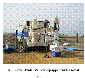 There are two interchangeable varieties of the GPR system depending
on operational conditions?a high-speed model and a soil-type adaptation model. Metal-collection
electromagnets and air blowers can also be attached to the vehicle’s robot arm.
To obtain detailed underground data for imaging, accurate positioning of the sensor
is necessary. A handheld GPR-MD system developed as a part of the project can
also produce imaging data, but inaccuracies due to movement of the user’s hands
must be taken into account. However, the highly accurate position control of
the main system’s robotic arm makes it possible to acquire extremely clear
underground images. The clearer imaging afforded by correct positioning of the
sensor is a practical example of Japan’s
leadership in advanced robotics.
There are two interchangeable varieties of the GPR system depending
on operational conditions?a high-speed model and a soil-type adaptation model. Metal-collection
electromagnets and air blowers can also be attached to the vehicle’s robot arm.
To obtain detailed underground data for imaging, accurate positioning of the sensor
is necessary. A handheld GPR-MD system developed as a part of the project can
also produce imaging data, but inaccuracies due to movement of the user’s hands
must be taken into account. However, the highly accurate position control of
the main system’s robotic arm makes it possible to acquire extremely clear
underground images. The clearer imaging afforded by correct positioning of the
sensor is a practical example of Japan’s
leadership in advanced robotics.
3. SAR-GPR CONCEPT
3.1 Concept of Development
Metal detectors, using electromagnetic
induction theory operating at around 10-100kHz have widely been used by many
demining operations in the world. Metal detectors are inexpensive, light weight
and easy-to-use tools, but it can detect only the existence of conducting materials.
In the real situations of humanitarian demining, the most serious problem is
that, although metal detectors can detect buried conducting materials, most of
them are not landmines, but fragments of barrel and metal debris. It causes
quite high fail alarm rate. On the contrary, Ground Penetrating Radar (GPR) can
be used for imaging tool due to its high resolution, therefore it would be
quite ideal for identification of buried objects that most metal detectors
cannot achieve. However, imaging by GPR is very difficult in strongly
inhomogeneous material due to strong clutter. We are proposing to use a synthetic
aperture radar (SAR) approach to solve this problem, and have developed a
SAR-GPR equipment. SAR-GPR is a combined sensor tool composed of a metal
detector and a array-antenna GPR equipments.
When a simple imaging by radar is difficult,
we can use a set of scanned radar data for further signal interpretation. This
can be achieved by solving inverse scattering problems, but it consumes much
time for computation. Another approach is migration signal processing, which
are simpler compared to inverse scattering approach, but much simpler and
robust. Migration processing, which is often used in geophysical exploration on
seismic and GPR is equivalent to synthetic aperture radar (SAR) processing,
widely used in remote sensing.
3.2
Array antenna and data acquisition
Landmines are targets which are buried in
shallow subsurface, normally less than 10cm. A GPR antenna has to have a good
electromagnetic coupling to subsurface material, so it has to be set very
closely to the ground surface. Hence, the distance to the buried target from
the antenna is less than 20cm. We are designing our GPR for the use in a very
dry conditions such as Afghanistan, therefore, we can use relatively high frequency compared to
conventional GPR applications, which normally use a frequency up to 1GHz. We
adopted an antipodal Vivaldi antenna for our GPR, because it has relatively
sharp radiation pattern in very broad frequency range, and it requires no
balance-unbalance transformation. At the same time, this type of antenna can be
fabricated easily, and suitable for an array antenna. We used FDTD for
designing the antenna, and the prototype antenna showed a good operation in the
frequency range of 1GHz and 4GHz.
The antennas will be scanned mechanically
near the ground surface and acquire the radar data. The data will be processed afterwards
for subsurface imaging. At the same time, we use an array antenna having 6
elements for data acquisition, in order to suppress the ground clutter. We
adopt a Common Midpoit (CMP) technique for gathering a data sets acquired at
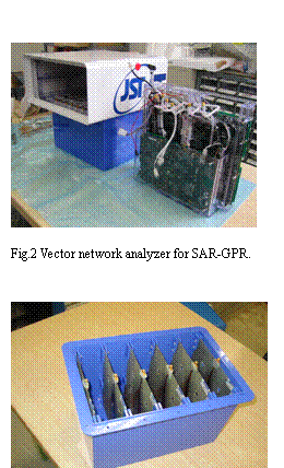
one position by the array antennas. Fig.2 shows the laboratory test of an array
antenna for SAR-GPR, which uses three normal vector network analyzers for data
acquisition. In the CMP technique, we acquire three sets of radar data using the
three pairs of antennas at one position. Fig.3 shows the antenna unit of
SAR-GPR to be mounted on Mine Hunter Vehicle.
Fig.3 shows the 6 Vivaldi antennas packed in
a plastic box, and Fig.4 shows the its test operation.
3.3 Compact vector network analyzer
In order to achieve the optimum SAR-GPR
performance, selection of adaptive operational frequency is quite important.
Also, antenna mismatching causes serious problems in GPR. Most of the
conventional GPR systems employed impulse radar, because it is compact and data
acquisition is fast. However, most of the impulse radar system had disadvantages
such as instability in signal, especially time drift and jitter, strong
impedance mismatching to a coaxial cable, which causes serious ringing, and
fixed frequency range. Vector network analyzer is a synchronized transmitter-
receiver measurement equipment. It is composed of a synthesizer and coherent
receiver. It enables quite flexible selection of operation frequencies, and
stable data acquisition. In addition, commercial vector network analyzers are
equipped with a calibration function, which masks impedance mismatching caused
by RF hardware. Impedance matching of antennas to coaxial cables in GPR is
quite difficult in all the frequency range of operation. Therefore refection
caused by impedance mismatching returns to a generator, and signal wave
deforms. In order to avoid these effects, many GPR antennas adopt strong
damping by impedance loading, which decreases antenna efficiency. If we use a
vector network analyzer, reflection from antennas can be perfectly absorbed by
the vector network analyzer, therefore, we can operate antennas without heavily
impedance loading.
Table
1 Comparison of commercial and developed vector network analyzers (VNA)
|
|
Developed VNA
|
MS4624
|
E5071B
|
|
Measurement
|
S21
|
S21,S11,S22
|
S21,S11,S22
|
|
Operation condition
|
-20 - +50C
|
|
|
|
Frequency
|
100MHz-4GHz
|
10MHz-9GHz
|
300kHz-8.5GHz
|
|
Dynamic range
|
70dB
|
125dB
|
122dB
|
|
Acquisition rate
|
646pt/sec
|
6,500pts/s
|
10,000pts/s
|
|
Accuracy
|
±1dB
|
±1.5dB
|
±1dB
|
|
Power supply
|
DC12-15V, 15W
|
100-200V, 540W
|
100-200V
|
|
Size
|
250X170X60
|
352X222X457
|
|
|
Weight
|
3kg
|
25kg
|
17.5kg
|
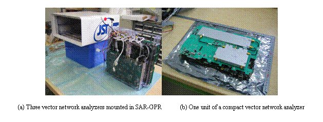 However, due to the large
size and weight, conventional network analyzer cannot be mounted in SAR-GPR. A
compact vector network analyzer has been available, which can be used field
measurement. However, the existing compact vector network analyzer had limited
frequency range, which cannot be adopted in GPR for landmine detection, and
data acquisition speed was too slow for practical use. Therefore, we develop a
new compact vector network analyzer which fits to our requirements. Table 1
show the comparison of the specifications of commercial and new vector network
analyzers. The prototype of the compact network analyzer was completed, and was
installed in the SAR-GPR system. In order to achieve fast data acquisition,
three vector network analyzers were installed, and they synchronize and acquire
data works simultaneously.
However, due to the large
size and weight, conventional network analyzer cannot be mounted in SAR-GPR. A
compact vector network analyzer has been available, which can be used field
measurement. However, the existing compact vector network analyzer had limited
frequency range, which cannot be adopted in GPR for landmine detection, and
data acquisition speed was too slow for practical use. Therefore, we develop a
new compact vector network analyzer which fits to our requirements. Table 1
show the comparison of the specifications of commercial and new vector network
analyzers. The prototype of the compact network analyzer was completed, and was
installed in the SAR-GPR system. In order to achieve fast data acquisition,
three vector network analyzers were installed, and they synchronize and acquire
data works simultaneously.
3.4 Image
reconstruction algorithm
Two-stage signal processing was carried out
after the acquired data was transformed into time-domain data by inverse Fourier
transformation. At first, the CMP stacking was carried out for suppression of
ground clutter. In this processing, 5 data sets acquired at one position is
stacked by calculating the time delay differences due to different propagation
length between antenna sets. Clutter from the ground surface and homogeneous
gravel can be suppressed by this CMP processing. The stacked signal is then
processed by the diffraction stacking algorithm and a 3D image is
reconstructed. The diffraction stacking is one of the standard migration
algorithms used for GPR and seismic measurement. The reconstructed image  by the diffraction
stacking is given by
by the diffraction
stacking is given by
 (1)
(1)
where  is the measured signal at the antenna position
  at time
  where
where
 (2)
(2)
is the travel time from the antenna position
to the focusing point, and  is the assumed velocity of wave in the material.
At the same time, we are developing more
advanced signal processing which can be used together with SAR-GPR. We are
planning to use the GPR data set for estimation of ground surface topography,
and estimation of velocity model, which can be implemented in the image
reconstruction algorithm
3.5 Metal detector
We believe that detection of buried landmine
from GPR image is too difficult in practical situation, because the GPR mages
is always suffered artifacts caused by strong clutter, even in SAR-GPR signal
processing was adopted. Therefore, all the judgment of data is carried out by
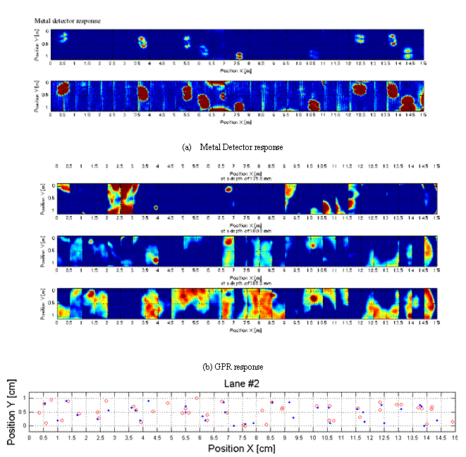
combination of metal detector information. CEIA MIL-D1 sensor was equipped on
the SAR-GPR system, and the metal detector signal is visualized at the same
time.
3.6
Laboratory evaluation test
Test measurement was carried out using a
sand box in laboratory condition, which simulates very rough ground conditions.
A sand box was filled with gravels having a diameter about 50mm and crashed
rocks having a diameter about 5mm. The averaged dielectric constant of the
mixed material is about 3.8, which was determined from the radar measurement.
The correlation length of the ground surface is 20mm and the RMS height is 15mm.
The radar target is a model of a plastic landmine Type-72. It contains very
small amount of metal part, and it is mostly filled with dielectric material.
This model has a cylindrical structure having a diameter of 78mm and the
thickness is 40mm. The antenna array was moved by a horizontal X-Y stage and
acquired the radar data at 1cm interval. The antenna height from the mean
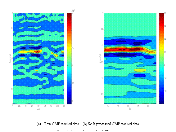
ground surface was about 50mm. Figure 6 and 7 show the GPR images of CMP stacked
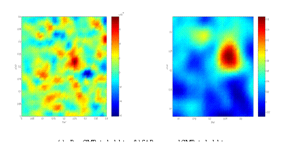
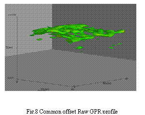
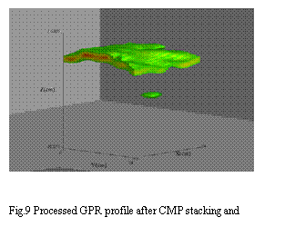
data, before and after SAR processing. Figures 8 and 9 show the 3-D GPR
reconstructed images. The effect of SAR processing is very clear and only after
SAR processing, buried landmine image can be clearly found in soil. Now we can
distinguish the reflections from the buried landmine model and the ground surface
separately.
We could find a good improvement of GPR
image by using the CMP and migration. We tested this technique for different
conditions. We also tested the same material by changing the roughness
condition, because reconstructed image can be changed according to the each
shape of the ground surface. However, we could find that almost same quality of
image can be obtained if we use the same material as shown in Figs.6 and 7.
Figs. 8 and 9 compare the improvement of the
image quality by signal processing. Fig.10 Shows the SAR-GPR image acquired in
the evaluation test held in Japan in
March 2005.
4. CONCLUSION
SAR-GPR was designed and prototype was
produced. It is equipped with three sets of GPR systems having Vivaldi antenna
and a compact vector network analyzer. CMP and Kirchhoff type migration algorithm
was adopted, and we could show that the signal processing can reduce the ground
clutter quite well, and SAR-GPR can image buried landmines even in very high
inhomogeneous material case.
Acknowledgements
This work was supported by JST
(Japan Science and Technology Agency). A part of
this work is also supported by JSPS Grant-in-Aid for Scientific Research
(S)14102024. We thank Mr. Tatsuki Yagi for his
contribution in the fabrication and tuning of the system.
REFERENCES
[1]
M.Sato, Y.Hamada, X. Feng,
F.Kong,Z.Zeng, G. Fang,”GPR using an array antenna for landmine detection,”
Near Surface Geophysics, 2, pp3-9,2004.
[2]
X. Feng and M. Sato, “Pre-stack migration applied to GPR for
landmine detection,” Inverse problems, 20, pp1-17, 2004.
[3]
X. Feng,, Z. Zhou., T. Kobayashi, T.
Savelyev, J. Fujiwara and M. Sato, Estimation of ground surface topography and
velocity models by SAR-GPR and its application to landmine detection, Proc.
Detection and remediation technologies for mines and minelike targets X, March
2005.
[4] http://www.jst.go.jp/kisoken/jirai/EN/index-e.html